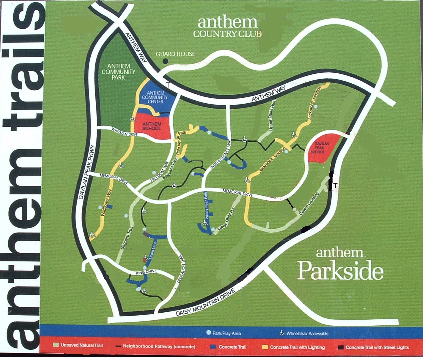
Anthem Trails in Area 1 (Central) – click map to enlarge
The trail map above is an updated version of an old one formerly posted at some trails. Presumably this map was prepared by Del Webb showing trail names chosen by the development team. The old map signs have now been replaced by new map signs with no trail names. On this site the original names will be used in the absence of newer “official” names.
The trails are listed below in west-to-east order from Gavilan Peak Pkwy to Daisy Mountain Dr, and the descriptions run from south to north:
WILDFLOWER WAY – this lighted concrete trail begins at Gavilan Peak Pkwy, runs up the wash east of Acadia Ct, crosses Memorial Dr and continues up the wash east of Courage Tr, crosses Whitman Dr and continues up the wash through Anthem Community Park. Between Gavilan and Memorial it connects to 3-JUBILATION/Acadia Park and to Morse Ct east of the wash. Between Memorial and Whitman there are no connections. Inside Anthem Community Park it connects to Anthem Community Center, to softball fields, and to the amphitheater, parking lot, play structure, Daisy Mountain Railroad, etc.
SAGUARO TRAIL – this unpaved natural trail begins at King Dr and runs north along the wash east of Patriot Way and National Tr, crosses Memorial Dr, and continues up the wash east of Freedom Way until ending at the Palo Verde Path complex. Between King and Memorial it connects to 4-JUBILATION/Patriot Park and to Webster Ct.
PALO VERDE PATH – this lighted concrete trail complex runs from Freedom Way near Anthem School across the wash to Capital Ct and Steinbeck Dr and also to Eagle Ct and Crockett Tr. The Capital/Steinbeck leg connects to Saguaro Trail.
LIZARD LANE – this unlighted concrete trail complex runs north from 2-INSPIRATIONS/Thoreau Park, crosses King Dr, then continues through 1-INSPIRATIONS/King Park up the wash and westward to 6-TRADITIONS/Exploration Park. Between Thoreau Ln and King Dr it connects to Integrity Tr. Between King Dr and Exploration Tr it connects to Honor Ct, Twain Ct, Dedication Way, and Integrity Tr.
PRICKLY PEAR PATH – this unlighted concrete trail runs from 7-ENCHANTMENT/Oakhurst Park (at the northeast end of Curie Ct) north to Memorial Dr. Along the way it connects to Gershwin Dr, Morse Ct, and Sousa Ct.
LOWER QUAIL RUN – this unpaved natural trail runs from the south end of Oakhurst Ct (with connection to 7-ENCHANTMENT/ Oakhurst Park) east and north to a crossing of Owens Dr, then north to Memorial Dr.
UPPER QUAIL RUN – this unpaved natural trail runs from Spirit Dr (between Prosperity Way and Majesty Way) north to Anthem Way.
JACKRABBIT JUNCTION – this lighted concrete trail begins a short distance south of Memorial Dr (between Majesty Tr and Fairgreen Way), runs north and across Memorial, up the wash and through 13-TAPESTRY/Steinbeck Park to a crossing of Wayne Ln, then through the west side of 12-REUNION/Yorktown Park and on to its ending at Anthem Way. South of Memorial this trail continues east as the unpaved natural Coyote Crossing. Between Memorial and Wayne it connects across the wash with Majesty Ct, across the wash with Whitman Ct and Majesty Way, and through 13-TAPESTRY/Steinbeck Park with Steinbeck Ct and Peale Ct.
COYOTE CROSSING – this unpaved natural trail begins at the south terminus of Jackrabbit Junction and runs east and then northeast to Daisy Mountain Dr and the tunnel under Daisy Mountain Dr. It has connections with Owens Way and 10-LEGACY/Adventure Park.
Go to Parks and Trails
Go to map of Parks and Trails in Area 1 (Central)
Go Home


